
Datasets:

The dataset viewer is not available for this subset.
Exception:    SplitsNotFoundError
Message:      The split names could not be parsed from the dataset config.
Traceback:    Traceback (most recent call last):
                File "/usr/local/lib/python3.14/site-packages/datasets/inspect.py", line 286, in get_dataset_config_info
                  for split_generator in builder._split_generators(
                                         ~~~~~~~~~~~~~~~~~~~~~~~~~^
                      StreamingDownloadManager(base_path=builder.base_path, download_config=download_config)
                      ^^^^^^^^^^^^^^^^^^^^^^^^^^^^^^^^^^^^^^^^^^^^^^^^^^^^^^^^^^^^^^^^^^^^^^^^^^^^^^^^^^^^^^
                  )
                  ^
                File "/usr/local/lib/python3.14/site-packages/datasets/packaged_modules/folder_based_builder/folder_based_builder.py", line 246, in _split_generators
                  raise ValueError(
                      "`file_name`, `*_file_name`, `file_names` or `*_file_names` must be present as dictionary key in metadata files"
                  )
              ValueError: `file_name`, `*_file_name`, `file_names` or `*_file_names` must be present as dictionary key in metadata files

              The above exception was the direct cause of the following exception:

              Traceback (most recent call last):
                File "/src/services/worker/src/worker/job_runners/config/split_names.py", line 66, in compute_split_names_from_streaming_response
                  for split in get_dataset_split_names(
                               ~~~~~~~~~~~~~~~~~~~~~~~^
                      path=dataset,
                      ^^^^^^^^^^^^^
                      config_name=config,
                      ^^^^^^^^^^^^^^^^^^^
                      token=hf_token,
                      ^^^^^^^^^^^^^^^
                  )
                  ^
                File "/usr/local/lib/python3.14/site-packages/datasets/inspect.py", line 340, in get_dataset_split_names
                  info = get_dataset_config_info(
                      path,
                  ...<6 lines>...
                      **config_kwargs,
                  )
                File "/usr/local/lib/python3.14/site-packages/datasets/inspect.py", line 291, in get_dataset_config_info
                  raise SplitsNotFoundError("The split names could not be parsed from the dataset config.") from err
              datasets.inspect.SplitsNotFoundError: The split names could not be parsed from the dataset config.
Need help to make the dataset viewer work? Make sure to review how to configure the dataset viewer, and open a discussion for direct support.
SEN2NEON (Validation Subset)
LR/HR Multispectral Super‑Resolution Dataset for benchmarking and research.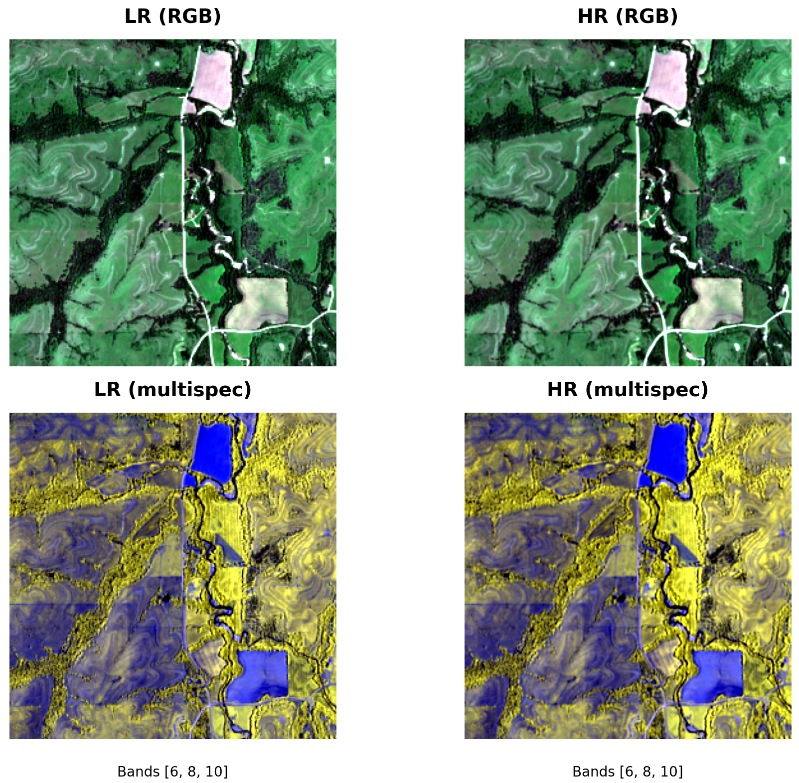
Dataset Summary
SEN2NEON provides paired low‑resolution (LR, 10 m) and high‑resolution (HR, 2.5 m) GeoTIFF tiles for validating super‑resolution (SR) models in remote sensing. Each pair shares the same spatial footprint; HR is an integer 4× upsample of LR and is pixel‑aligned. A companion metadata.jsonl/CSV file supplies per‑tile metadata and land‑cover labels to enable stratified evaluation (e.g., Forest vs Built‑up).
The code, examples and validation workflowws can be found at ESAOpenSR/SEN2NEON.
- Modality: Multispectral GeoTIFFs (band count may vary by source preprocessing)
- Tasks: Super‑resolution (image‑to‑image), benchmarking & analysis
- Scale: ~30 GB total (varies by release)
- Alignment: HR is 4× LR; integer, isotropic scale; pixel‑aligned
- Geo: UTM/ETRS zones per tile (see
crsin CSV);lon/latprovided for centroids
Repository Layout
.
├── metadata.jsonl              # line‑delimited JSON index (recommended entry point)
├── sen2neon_metadata.csv       # CSV index (same content as JSONL, tabular form)
├── neon_10m_linearized/        # LR tiles (GeoTIFF)
└── neon_2.5m_linearized/       # HR tiles (GeoTIFF)
Relative paths in the JSON/CSV (e.g., neon_10m_linearized/…) match the on‑hub layout.
Record Schema (metadata.jsonl)
Each line is one sample:
{
  "id": "<stem>",
  "lr": "neon_10m_linearized/<file>.tif",
  "hr": "neon_2.5m_linearized/<file>.tif",
  "split": "val",
  "name": "<filename.tif>",
  "lon": <float or null>,
  "lat": <float or null>,
  "LC_detail_id": <int or null>,
  "LC_detail_text": "<str or null>",
  "LC_superclass_id": <int or null>,
  "LC_superclass_text": "<str or null>"
}
Notes:
splitis set to"val"for this release.lon/latare WGS84 centroids; may be null for tiles outside coverage.- LC fields come from the categorical land‑cover raster used in preprocessing (see below).
Quick Download
Using the Hub snapshot cache (resumable, selective patterns):
pip install -U huggingface_hub
python - <<'PY'
from huggingface_hub import snapshot_download
snapshot_download(
    repo_id="simon-donike/SEN2NEON",
    repo_type="dataset",
    local_dir="./data/sen2neon",
    allow_patterns=[
        "metadata.jsonl",
        "sen2neon_metadata.csv",
        "neon_10m_linearized/**",
        "neon_2.5m_linearized/**"
    ],
)
PY
(For high‑throughput, you can pip install hf_transfer and set HF_HUB_ENABLE_HF_TRANSFER=1.)
Load with 🤗 Datasets (Streaming, no full download)
from datasets import load_dataset, Image

# Stream JSONL, keep paths relative to the Hub
ds = load_dataset(
    "json",
    data_files="hf://datasets/simon-donike/SEN2NEON/metadata.jsonl",
    split="train",  # streaming uses a single split; filter by 'split' field if needed
    streaming=True
)

# Cast path fields to Image feature to lazily fetch TIFFs
ds = ds.cast_column("lr", Image())
ds = ds.cast_column("hr", Image())

row = next(iter(ds))
lr_img = row["lr"]  # dict with 'path' and PIL image accessor
hr_img = row["hr"]
print(row["id"], row.get("LC_superclass_text"))
Load with PyTorch (Local Files)
After downloading (e.g., into ./data/sen2neon/), you can use the provided CSV‑driven loader:
from data.sen2neon_ds import SEN2NEON
from torch.utils.data import DataLoader

root = "./data/sen2neon"
csv  = f"{root}/sen2neon_metadata.csv"

ds = SEN2NEON(csv_path=csv, root_dir=root, crop_size_lr=None)
loader = DataLoader(ds, batch_size=2, shuffle=True, num_workers=4, pin_memory=True)

batch = next(iter(loader))
lr, hr, meta = batch["lr"], batch["hr"], batch["meta"]
print(lr.shape, hr.shape, meta["LC_superclass_text"][:2])
Land‑cover Integration
Each sample is joined with land‑cover information derived from an external categorical land‑cover raster covering the study area. The LR tile footprint is reprojected to the LC CRS; the mode value within that window is taken as the label.
LC_detail_id/LC_detail_text: fine‑grained class (e.g., 41 → “Deciduous”).LC_superclass_id/LC_superclass_text: coarser super‑group (e.g., 40 → “Forest”, 50 → “Built‑up”).- These fields enable stratified metrics (e.g., PSNR/SSIM/SAM) by environment type.
- Missing values may occur (outside coverage / NoData).
Geospatial & Data Notes
- CRS: Tiles are stored in per‑scene/projected UTM/ETRS zones; see
crsin the CSV (when available). Centroids are additionally provided as WGS84 (lon/lat). - Alignment: HR is an exact 4× integer scaling of LR with pixel‑grid alignment.
- Nodata: TIFF
nodatavalues are respected; downstream loaders may map them to NaN. - Bands: Band count may vary across scenes; code examples select RGB if available (else fallbacks).
Intended Uses
- Benchmarking SR models (classical, CNN, diffusion, GANs).
- Stratified evaluation by land‑cover class (robust performance reporting).
- Qualitative visualization and error analysis.
Limitations
- Land‑cover labels are window‑mode summaries, not per‑pixel annotations.
- Some tiles may lack LC labels or have ambiguous boundaries near class transitions.
- Sensor mix / preprocessing differences can affect cross‑domain generalization.
License
Please refer to the dataset repository license on the Hub page. If you fork/modify, include the original attribution. (Contact the maintainers for commercial/redistribution questions.)
Citation
If you use SEN2NEON in your research, please cite the dataset and the accompanying tools. A publication is in the works.
Contact
- Maintainer: Image Processing Laboratory, University of Valencia, Spain
- Issues & questions: open a discussion on the linked GitHub repository.
- Downloads last month
- 829